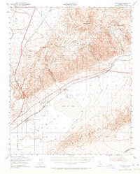
1943 Map of Saltdale
USGS Topo · Published 1965About this map
The El Paso Mountains and Rand Mountains dominate this high-desert landscape, framing the expansive Koehn Dry Lake in the southern basin. During the mid-1940s, this region was a hub of extraction and military utility, evidenced by the numerous mining operations such as the Holly Mine, Smith Mine, and Copper Basin Mine scattered through the canyons. The presence of the Arty Ground Observation Sta near the Petrified Forest highlights the area's strategic wartime role. Transportation was anchored by the Southern Pacific railroad, which served remote stops like Saltdale and Garlock Sta. Local life centered around small desert outposts and the Redrock Sch, while natural landmarks like Redrock Canyon and Last Chance Canyon provided distinctive geological orientation for travelers on the Neuralia Road.
Find a feature on this map
38 named features on this map. Tap any name to fly to it.
Don’t see what you’re looking for? This feature index may not catch every label — zoom into the map to look around manually.
Map Details
Editions of this 1943 Saltdale Map
4 editions found
Other maps of this area

1903 · Randsburg
USGS Topo · 1:62,500

1906 · Kernville
USGS Topo · 1:125,000

1908 · Kernville
USGS Topo · 1:125,000

1911 · Randsburg
USGS Topo · 1:62,500

1912 · Randsburg
USGS Topo · 1:62,500

1915 · Searles Lake
USGS Topo · 1:250,000

1915 · Mojave
USGS Topo · 1:125,000

1943 · Inyokern
USGS Topo · 1:62,500

1943 · Cross Mountain
USGS Topo · 1:62,500

1943 · Saltdale
USGS Topo · 1:62,500