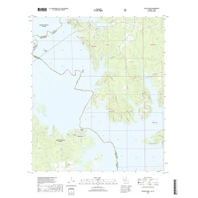
2018 Map of Salter Creek
USGS Topo · Published 2018About this map
Toledo Bend Reservoir dominates the landscape of this border region where Texas meets Louisiana. This survey details the complex, finger-like shorelines of the reservoir, a landscape shaped by the flooding of the Sabine River valley. The map reveals the interplay between public conservation lands and local family history, with large portions of the Sabine National Forest bordering the water. Notable historical sites include the settlement of Sabinetown, where the Sabinetown Cem remains a primary landmark. Further south along the banks, Goodloe Bluff and Stone Coal Bluff mark significant topographic rises above the water level. Throughout the wooded terrain, researchers will find numerous small cemeteries like Gandy Cem and Harper's Chapel Cem, which serve as some of the few remaining markers of the rural communities that existed before the reservoir's creation.
Find a feature on this map
78 named features on this map. Tap any name to fly to it.
Don’t see what you’re looking for? This feature index may not catch every label — zoom into the map to look around manually.
Map Details
Editions of this 2018 Salter Creek Map
This is the sole edition of this map. No revisions or reprints were ever made.
Other maps of this area

1941 · Zwolle
USGS Topo · 1:62,500

1944 · Negreet
USGS Topo · 1:62,500

1944 · Patroon
USGS Topo · 1:62,500

1944 · Zwolle
USGS Topo · 1:62,500

1953 · Alexandria
USGS Topo · 1:250,000

1954 · Toro
USGS Topo · 1:24,000

1954 · Columbus
USGS Topo · 1:24,000
1954 · Negreet
USGS Topo · 1:24,000

1954 · Negreet
USGS Topo · 1:62,500

1954 · Salter Creek
USGS Topo · 1:24,000