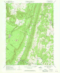
1968 Map of Saltillo
USGS Topo · Published 1970About this map
Robertsdale and Saltillo anchor this 1968 study of the Ridge and Valley landscape, where industrial extraction and isolated rural communities intersect. The map documents a territory defined by the anthracite coal industry, specifically the presence of numerous Strip Mines and an old railroad grade cutting through the western terrain. The settlement pattern follows the narrow valleys between Jacks Mountain and Sideling Hill, revealing a network of country institutions like the Spring Farm Sch and Cornelius Chapel.
Find a feature on this map
62 named features on this map. Tap any name to fly to it.
Don’t see what you’re looking for? This feature index may not catch every label — zoom into the map to look around manually.
Map Details
Editions of this 1968 Saltillo Map
3 editions found
Other maps of this area

1901 · Huntingdon
USGS Topo · 1:62,500

1904 · Huntingdon
USGS Topo · 1:62,500

1922 · Mt Union
USGS Topo · 1:48,000

1924 · Mt. Union
USGS Topo · 1:62,500

1930 · Broad Top
USGS Topo · 1:62,500

1933 · Broad Top
USGS Topo · 1:62,500

1939 · Orbisonia
USGS Topo · 1:62,500

1940 · Orbisonia
USGS Topo · 1:62,500

1944 · Orbisonia
USGS Topo · 1:62,500

1944 · Mt. Union
USGS Topo · 1:62,500