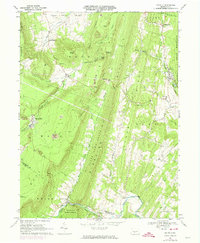
1968 Map of Saltillo
USGS Topo · Published 1974About this map
The Trough Creek Valley and its surrounding ridgelines define the landscape of this portion of Huntingdon and Fulton Counties. Central to the area is the borough of Saltillo, where the local geography is shaped by the presence of Jacks Mountain and Clear Ridge. The map documents a transition in land use, showing several Strip Mines and other Mines alongside the expansive State Game Lands No 67 and Buchanan State Forest.
Find a feature on this map
61 named features on this map. Tap any name to fly to it.
Don’t see what you’re looking for? This feature index may not catch every label — zoom into the map to look around manually.
Map Details
Editions of this 1968 Saltillo Map
3 editions found
Other maps of this area

1901 · Huntingdon
USGS Topo · 1:62,500

1904 · Huntingdon
USGS Topo · 1:62,500

1922 · Mt Union
USGS Topo · 1:48,000

1924 · Mt. Union
USGS Topo · 1:62,500

1930 · Broad Top
USGS Topo · 1:62,500

1933 · Broad Top
USGS Topo · 1:62,500

1939 · Orbisonia
USGS Topo · 1:62,500

1940 · Orbisonia
USGS Topo · 1:62,500

1944 · Orbisonia
USGS Topo · 1:62,500

1944 · Mt. Union
USGS Topo · 1:62,500