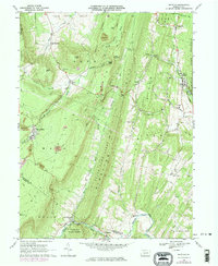
1968 Map of Saltillo
USGS Topo · Published 1974About this map
Sideling Hill and Jacks Mountain dominate this landscape in southern Huntingdon County, where the ridge-and-valley terrain dictated the paths of early industry and settlement. Industrial activity is visible through numerous Strip Mines and the presence of an Old Railroad Grade winding through the gaps, reflecting the area's history with coal and timber. The small communities of Saltillo, Robertsdale, and Joller are linked by these corridors, while remote hillsides are dotted with rural landmarks like Spring Farm Sch and Kimmel Ch.
Find a feature on this map
63 named features on this map. Tap any name to fly to it.
Don’t see what you’re looking for? This feature index may not catch every label — zoom into the map to look around manually.
Map Details
Editions of this 1968 Saltillo Map
3 editions found
Other maps of this area

1901 · Huntingdon
USGS Topo · 1:62,500

1904 · Huntingdon
USGS Topo · 1:62,500

1922 · Mt Union
USGS Topo · 1:48,000

1924 · Mt. Union
USGS Topo · 1:62,500

1930 · Broad Top
USGS Topo · 1:62,500

1933 · Broad Top
USGS Topo · 1:62,500

1939 · Orbisonia
USGS Topo · 1:62,500

1940 · Orbisonia
USGS Topo · 1:62,500

1944 · Orbisonia
USGS Topo · 1:62,500

1944 · Mt. Union
USGS Topo · 1:62,500