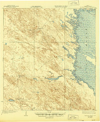
1923 Map of Saltillo Ranch
USGS Topo · Published 1944About this map
Large isolated ranching operations define the coastal prairie of Kenedy County in this early 1920s survey. Key inland outposts like Saltillo Ranch and San Ignacio Ranch anchor a landscape reliant on scattered groundwater sources, evidenced by named sites such as Mayote Wells and San Francisco Well. The eastern edge of the map is dominated by the intricate shoreline of the Laguna Madre, where the shallow hypersaline lagoon meets the mainland, including the nearby landform of Lopena Island. The network of unimproved trails connecting San Pedro Ranch and Los Tajos Ranch illustrates the remote nature of South Texas cattle country before modern infrastructure reached this stretch of the Gulf Coast. The sparse distribution of wells and ranch houses highlights a way of life deeply tied to the natural hydrology of the brush country.
Find a feature on this map
10 named features on this map. Tap any name to fly to it.
Don’t see what you’re looking for? This feature index may not catch every label — zoom into the map to look around manually.
Map Details
Editions of this 1923 Saltillo Ranch Map
2 editions found
Other maps of this area

1921 · Tarida Ranch
USGS Topo · 1:62,500

1922 · La Sal Vieja
USGS Topo · 1:62,500

1923 · Armstrong
USGS Topo · 1:62,500

1923 · Lopena Island
USGS Topo · 1:62,500

1923 · Saltillo Ranch
USGS Topo · 1:62,500

1928 · Sarita
USGS Topo · 1:125,000

1950 · Corpus Christi
USGS Topo · 1:250,000

1951 · Potrero Lopeno NW
USGS Topo · 1:24,000

1952 · Potrero Cortado
USGS Topo · 1:24,000

1952 · South of Potrero Lopeno NW
USGS Topo · 1:24,000