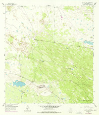
1956 Map of Saltillo Well
USGS Topo · Published 1977About this map
The Norias Headquarters King Ranch anchor this landscape in Kenedy County, serving as a hub for ranching operations in a remote stretch of South Texas. This 1956 survey, updated with 1975 revisions, reveals a terrain defined by extensive fencing and a critical network of water sources. The map details numerous water features essential for cattle, ranging from windmills like the Chicago Windmill to specialized artesian wells such as the Salvador Artesian Well and La Fortuna Artesian Well.
Find a feature on this map
25 named features on this map. Tap any name to fly to it.
Don’t see what you’re looking for? This feature index may not catch every label — zoom into the map to look around manually.
Map Details
Editions of this 1956 Saltillo Well Map
2 editions found
Other maps of this area

1921 · Tarida Ranch
USGS Topo · 1:62,500

1922 · La Sal Vieja
USGS Topo · 1:62,500

1923 · Armstrong
USGS Topo · 1:62,500

1923 · Saltillo Ranch
USGS Topo · 1:62,500

1953 · Brownsville
USGS Topo · 1:250,000
1956 · Armstrong
USGS Topo · 1:24,000
1956 · San Pedro Ranch
USGS Topo · 1:24,000

1956 · Saltillo Well
USGS Topo · 1:24,000
1956 · Maria Estella Well
USGS Topo · 1:24,000

1956 · Rudolph
USGS Topo · 1:24,000