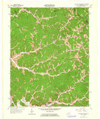
1962 Map of Salyersville North
USGS Topo · Published 1964About this map
The Licking River and its intricate network of tributaries define this part of the Cumberland Plateau in the early 1960s. The landscape is characterized by narrow hollows and ridge-top settlements, where communities like Lickburg, Hammond, and Logville developed along the creek beds. A significant amount of local infrastructure is dedicated to education and faith, evidenced by the numerous small schoolhouses such as Jenkins Sch and Beech Grove Sch, and rural landmarks like Buffalo Ch. The map captures a moment of modern transition with the presence of the Mountain Parkway cutting through the southern portion near Salyersville. This infrastructure sits alongside a traditional rural economy, where dozens of Oil Wells and a Quarry are scattered among family-named landmarks and cemeteries including Franklin Cem and Mouth of Lacey Cem.
Find a feature on this map
95 named features on this map. Tap any name to fly to it.
Don’t see what you’re looking for? This feature index may not catch every label — zoom into the map to look around manually.
Map Details
Editions of this 1962 Salyersville North Map
Other maps of this area

1886 · Prestonsburg
USGS Topo · 1:125,000

1889 · Salyersville
USGS Topo · 1:125,000

1891 · Salyersville
USGS Topo · 1:125,000

1892 · Prestonsburg
USGS Topo · 1:125,000

1899 · Salyersville
USGS Topo · 1:125,000

1915 · Paintsville
USGS Topo · 1:48,000

1915 · Prestonsburg
USGS Topo · 1:62,500

1917 · Paintsville
USGS Topo · 1:62,500

1918 · Prestonsburg
USGS Topo · 1:62,500

1950 · Lenox
USGS Topo · 1:24,000