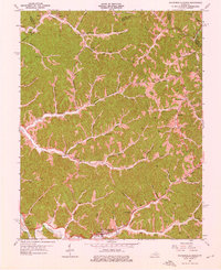
1962 Map of Salyersville North
USGS Topo · Published 1976About this map
Licking River valley settlements define this portion of Magoffin County, where the southern edge of the map features the established seat of Salyersville. The landscape in the early 1960s is characterized by a dense network of mountain communities such as Lickburg, Gifford, and Falcon, many of which developed around the forks of the river and its numerous tributaries like Raccoon Creek and Buffalo Creek. This era shows the region's reliance on natural resources, evidenced by a scattering of Gas Wells and Oil Wells across the hillsides, alongside essential social hubs like Buffalo Ch and Freewill Ch.
Find a feature on this map
94 named features on this map. Tap any name to fly to it.
Don’t see what you’re looking for? This feature index may not catch every label — zoom into the map to look around manually.
Map Details
Editions of this 1962 Salyersville North Map
Other maps of this area

1886 · Prestonsburg
USGS Topo · 1:125,000

1889 · Salyersville
USGS Topo · 1:125,000

1891 · Salyersville
USGS Topo · 1:125,000

1892 · Prestonsburg
USGS Topo · 1:125,000

1899 · Salyersville
USGS Topo · 1:125,000

1915 · Paintsville
USGS Topo · 1:48,000

1915 · Prestonsburg
USGS Topo · 1:62,500

1917 · Paintsville
USGS Topo · 1:62,500

1918 · Prestonsburg
USGS Topo · 1:62,500

1950 · Lenox
USGS Topo · 1:24,000