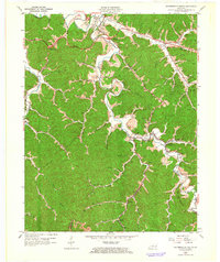
1962 Map of Salyersville South
USGS Topo · Published 1964About this map
The Licking River carves a winding path through the deeply dissected plateau of Magoffin County, dictating the development of early 1960s settlements and industry. The Chesapeake and Ohio railroad follows the valley floor, linking rural communities like Sublett and Royalton to the broader regional coal and timber markets. Evidence of the area's resource-based economy is scattered across the terrain, from a Strip Mine on the eastern hills to the numerous gas wells and the pipeline traversing the ridges. Genealogists will find a dense concentration of family landmarks, including the Howard-Shepard Cem, Gardner Cem, and Powers Cem. The landscape is dominated by significant elevations such as Big Half Mountain and Gully Mountain, while the nascent transportation network is highlighted by the Parkway Toll Road and modern interchanges near Salyersville.
Find a feature on this map
66 named features on this map. Tap any name to fly to it.
Don’t see what you’re looking for? This feature index may not catch every label — zoom into the map to look around manually.
Map Details
Editions of this 1962 Salyersville South Map
3 editions found
Other maps of this area

1886 · Prestonsburg
USGS Topo · 1:125,000

1889 · Salyersville
USGS Topo · 1:125,000

1891 · Salyersville
USGS Topo · 1:125,000

1892 · Prestonsburg
USGS Topo · 1:125,000

1899 · Salyersville
USGS Topo · 1:125,000

1915 · Paintsville
USGS Topo · 1:48,000

1915 · Prestonsburg
USGS Topo · 1:62,500

1917 · Paintsville
USGS Topo · 1:62,500

1918 · Prestonsburg
USGS Topo · 1:62,500

1951 · Tiptop
USGS Topo · 1:24,000