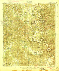
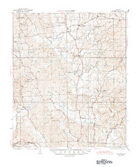
1928 Map of Samantha
USGS Topo · Published 1928About this map
The Sipsey River and the North River define the winding, creek-cut landscape of Tuscaloosa County in the mid-1920s. This survey, conducted by J.M. Rawls and W.C. Thompson, reveals a rural network deeply rooted in localized community hubs like Samantha and Bell City. The historical Byler Road traverses the terrain, a critical overland route connecting these upland settlements. In the southwestern corner, the Mobile and Ohio RR serves the station at Buhl, providing a vital rail link for the local economy. Throughout the quadrangle, a dense concentration of small churches and schools, such as Phillips Chapel, Haygood Chapel, and Bethabara Sch, illustrates the era's social geography where most daily life happened within a few miles of one's front door. Researchers will also find family-named landmarks like Longs Store and Skelton Bend that mark the legacy of early residents.
Find a feature on this map
59 named features on this map. Tap any name to fly to it.
Don’t see what you’re looking for? This feature index may not catch every label — zoom into the map to look around manually.
Map Details
Editions of this 1928 Samantha Map
6 editions found
Other maps of this area

1893 · Jasper
USGS Topo · 1:125,000

1899 · Brookwood
USGS Topo · 1:125,000

1924 · Tuscaloosa
USGS Topo · 1:62,500

1926 · Samantha
USGS Topo · 1:48,000

1926 · Tuscaloosa
USGS Topo · 1:62,500

1928 · Samantha
USGS Topo · 1:62,500

1929 · Searles
USGS Topo · 1:48,000

1931 · Cottondale
USGS Topo · 1:48,000

1934 · Searles
USGS Topo · 1:62,500

1934 · Cottondale
USGS Topo · 1:62,500