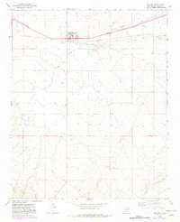
1968 Map of San Jon
USGS Topo · Published 1982About this map
San Jon serves as the focal point of this eastern New Mexico survey, positioned where the legendary Route 66 and Interstate 40 converge. The town's layout is clearly defined, featuring local infrastructure like a Sewage Disposal plant and a nearby Landing Strip. The surrounding rangeland in Quay County is marked by essential water sources for cattle and transit, including West Well and the South Coffman Windmill.
Find a feature on this map
13 named features on this map. Tap any name to fly to it.
Don’t see what you’re looking for? This feature index may not catch every label — zoom into the map to look around manually.
Map Details
Editions of this 1968 San Jon Map
3 editions found
Other maps of this area

1954 · Tucumcari
USGS Topo · 1:250,000

1954 · Clovis
USGS Topo · 1:250,000

1958 · Clovis
USGS Topo · 1:250,000

1958 · Tucumcari
USGS Topo · 1:250,000

1968 · Porter
USGS Topo · 1:24,000

1968 · Riley Camp
USGS Topo · 1:24,000

1968 · San Jon
USGS Topo · 1:24,000

1968 · Bard
USGS Topo · 1:24,000

1968 · San Jon NW
USGS Topo · 1:24,000

1968 · Bedford Hill
USGS Topo · 1:24,000