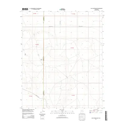
2013 Map of San Juan Mesa East
USGS Topo · Published 2013About this map
San Juan Mesa dominates the western portion of this 2013 survey, rising above the surrounding high plains of Eastern New Mexico. The boundary between Chaves and Roosevelt counties runs vertically through the center of the sheet, providing a precise record of the administrative divide in this rural landscape. The topography is defined by the gradual descent from the mesa into Falsey Draw, which cuts a path through the central sections. This map documents a grid of local infrastructure, primarily ranch roads and county routes such as S Roosevelt Road 19 and Co Road 24. The presence of Boone Ranch Rd indicates the continued agricultural and pastoral legacy of the area, where large landholdings are bisected by the Public Land Survey System township and range lines.
Find a feature on this map
15 named features on this map. Tap any name to fly to it.
Don’t see what you’re looking for? This feature index may not catch every label — zoom into the map to look around manually.
Map Details
Editions of this 2013 San Juan Mesa East Map
This is the sole edition of this map. No revisions or reprints were ever made.
Other maps of this area

1954 · Clovis
USGS Topo · 1:250,000

1954 · Brownfield
USGS Topo · 1:250,000

1958 · Brownfield
USGS Topo · 1:250,000

1958 · Clovis
USGS Topo · 1:250,000

1962 · Brownfield
USGS Topo · 1:250,000

1973 · Lewiston Lake
USGS Topo · 1:24,000

1973 · Gammil Well SE
USGS Topo · 1:24,000
1973 · Rippee Ranch
USGS Topo · 1:24,000
1978 · Elida
USGS Topo · 1:24,000

1979 · Kenna
USGS Topo · 1:24,000