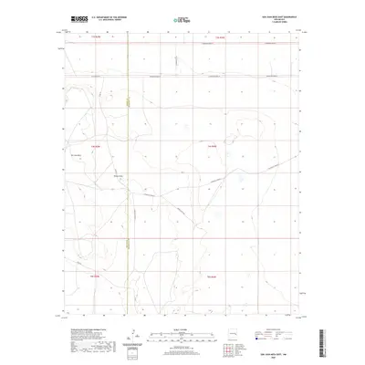
2020 Map of San Juan Mesa East
USGS Topo · Published 2020About this map
San Juan Mesa dominates the high ground of this eastern New Mexico landscape, straddling the border between Chaves and Roosevelt counties. This 2020 survey illustrates a characteristic Western ranching and transport grid, defined by long, straight stretches of road that follow section lines despite the underlying topography. The elevation drops sharply into Falsey Draw, a drainage feature that breaks the plateau in the western half of the map. Local access is provided by a network of ranch and county roads, including Boone Ranch Rd and San Patricio Rd, which connect isolated land parcels. The transition from the flat mesa tops to the recessed draws provides a clear look at the modern rural infrastructure used to navigate this arid environment.
Find a feature on this map
13 named features on this map. Tap any name to fly to it.
Don’t see what you’re looking for? This feature index may not catch every label — zoom into the map to look around manually.
Map Details
Editions of this 2020 San Juan Mesa East Map
This is the sole edition of this map. No revisions or reprints were ever made.
Other maps of this area

1954 · Clovis
USGS Topo · 1:250,000

1954 · Brownfield
USGS Topo · 1:250,000

1958 · Brownfield
USGS Topo · 1:250,000

1958 · Clovis
USGS Topo · 1:250,000

1962 · Brownfield
USGS Topo · 1:250,000

1973 · Lewiston Lake
USGS Topo · 1:24,000

1973 · Gammil Well SE
USGS Topo · 1:24,000
1973 · Rippee Ranch
USGS Topo · 1:24,000
1978 · Elida
USGS Topo · 1:24,000

1979 · Kenna
USGS Topo · 1:24,000