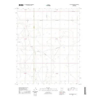
2023 Map of San Juan Mesa East
USGS Topo · Published 2023About this map
San Juan Mesa dominates the western portion of this high plains landscape, where the Chaves and Roosevelt county line bisects the arid terrain. The map captures a section of eastern New Mexico defined by large-scale ranching infrastructure and a geometric grid of rural roads. Significant drainages like Falsey Draw cut through the mesa, revealing the natural hydrology that dictates movement across this open country. The road network, including San Patricio Rd and Boone Ranch Rd, suggests the reach of local families and long-standing ranching operations. Along the Chaves Co Roosevelt Co boundary, the transition from tablelands to lower draws is marked by routes such as Olive Rd and S Roosevelt Road 22, providing a clear record of modern land use and historical property divisions in this isolated region.
Find a feature on this map
14 named features on this map. Tap any name to fly to it.
Don’t see what you’re looking for? This feature index may not catch every label — zoom into the map to look around manually.
Map Details
Editions of this 2023 San Juan Mesa East Map
This is the sole edition of this map. No revisions or reprints were ever made.
Other maps of this area

1954 · Clovis
USGS Topo · 1:250,000

1954 · Brownfield
USGS Topo · 1:250,000

1958 · Brownfield
USGS Topo · 1:250,000

1958 · Clovis
USGS Topo · 1:250,000

1962 · Brownfield
USGS Topo · 1:250,000

1973 · Lewiston Lake
USGS Topo · 1:24,000

1973 · Gammil Well SE
USGS Topo · 1:24,000
1973 · Rippee Ranch
USGS Topo · 1:24,000
1978 · Elida
USGS Topo · 1:24,000

1979 · Kenna
USGS Topo · 1:24,000