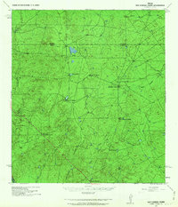
1940 Map of San Loranzo Creek
USGS Topo · Published 1963About this map
San Lorenzo Creek meanders through this portion of the South Texas brush country, where the landscape is defined by the cattle-ranching economy of the mid-twentieth century. The map reveals a pattern of dispersed, large-scale holdings centered on water sources, such as the Ojita Tank and Tordillo Tank, which were vital for livestock in this arid environment. Named family operations like Brown Ranch, Espejo Ranch, and Puig Ranch serve as primary landmarks across the rolling terrain. The presence of a Goat Camp and unnamed Ruins in the northwest suggests the remnants of earlier pastoral life or short-lived homesteads. Topographic features such as the Dos Hermanos Peaks and the winding course of Santa Alvada Creek provide natural orientation within this expanse along the Dimmit and Webb County line. The survey, compiled from field work by the 2d and 8th Engineers, offers a clear record of rural infrastructure before modern development.
Find a feature on this map
19 named features on this map. Tap any name to fly to it.
Don’t see what you’re looking for? This feature index may not catch every label — zoom into the map to look around manually.
Map Details
Editions of this 1940 San Loranzo Creek Map
3 editions found
Other maps of this area

1923 · Palafox
USGS Topo · 1:62,500

1929 · Cotulla
USGS Topo · 1:125,000

1932 · Valley Wells
USGS Topo · 1:62,500

1940 · Asherton
USGS Topo · 1:62,500

1940 · Velenzuela Creek
USGS Topo · 1:62,500

1940 · San Loranzo Creek
USGS Topo · 1:62,500

1940 · Catarina
USGS Topo · 1:62,500

1940 · Chupadera
USGS Topo · 1:62,500

1941 · Botella Creek
USGS Topo · 1:62,500

1953 · Crystal City
USGS Topo · 1:250,000