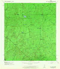
1940 Map of San Loranzo Creek
USGS Topo · Published 1967About this map
The borderlands between Dimmit and Webb counties reveal a landscape defined by expansive cattle operations and critical water management during the early 1940s. Centered around San Lorenzo Creek, the area is punctuated by family-held ranching estates including Brown Ranch, Espejo Ranch, and Roberts Ranch. These outposts are supported by a network of man-made reservoirs like Ojita Tank and Tordillo Tank, essential for survival in this arid Brush Country environment. The terrain is largely dominated by ephemeral drainages such as Tierra Blanca Creek and Espada Creek, while the Dos Hermanos Peaks provide a rare topographical anchor in the otherwise undulating plains. To the south, Espada Ranch and Puig Ranch sit along the winding path of Santa Alvido Creek, marking the deep-rooted ranching heritage that persisted even as military surveys like those from the Corps of Engineers and U.S. Army Air Corps documented the region.
Find a feature on this map
18 named features on this map. Tap any name to fly to it.
Don’t see what you’re looking for? This feature index may not catch every label — zoom into the map to look around manually.
Map Details
Editions of this 1940 San Loranzo Creek Map
3 editions found
Other maps of this area

1923 · Palafox
USGS Topo · 1:62,500

1929 · Cotulla
USGS Topo · 1:125,000

1932 · Valley Wells
USGS Topo · 1:62,500

1940 · Asherton
USGS Topo · 1:62,500

1940 · Velenzuela Creek
USGS Topo · 1:62,500

1940 · San Loranzo Creek
USGS Topo · 1:62,500

1940 · Catarina
USGS Topo · 1:62,500

1940 · Chupadera
USGS Topo · 1:62,500

1941 · Botella Creek
USGS Topo · 1:62,500

1953 · Crystal City
USGS Topo · 1:250,000