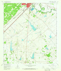
1964 Map of San Marcos South
USGS Topo · Published 1966About this map
San Marcos River flows through the northern reaches of this mid-1960s landscape, just south of the main city center where the State Fish Hatchery and Municipal Airport are established. The terrain is defined by its drainage systems, including Purgatory Creek, Cottonwood Creek, and York Creek, which cut through the limestone and clay of the central Texas corridor. Settlement patterns here are deeply rooted in the agricultural history of Hays and Guadalupe counties, anchored by the small communities of Centerpoint and Zorn. A significant infrastructure network of rail and road connects these rural outposts, most notably the dual lines of the Missouri Pacific Texas and Pacific and the Missouri Kansas Texas railroads. Genealogists will find particular value in the dispersed burial grounds such as Pitts Cem, San Pedro Cem, and Bading Cem, which mark the early homesteads and community hubs of this rural expanse.
Find a feature on this map
28 named features on this map. Tap any name to fly to it.
Don’t see what you’re looking for? This feature index may not catch every label — zoom into the map to look around manually.
Map Details
Editions of this 1964 San Marcos South Map
3 editions found
Other maps of this area

1911 · San Marcos
USGS Topo · 1:125,000

1919 · San Marcos
USGS Topo · 1:125,000

1925 · New Braunfels No 1
USGS Topo · 1:48,000

1927 · New Braunfels
USGS Topo · 1:62,500

1929 · Hunter
USGS Topo · 1:62,500

1930 · Seguin
USGS Topo · 1:62,500

1953 · Seguin
USGS Topo · 1:250,000

1954 · San Antonio
USGS Topo · 1:250,000

1957 · San Antonio
USGS Topo · 1:250,000

1958 · Seguin
USGS Topo · 1:250,000