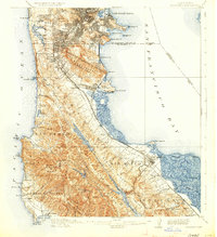
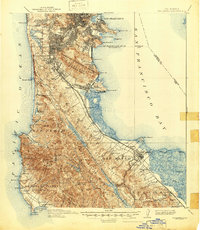
1915 Map of San Mateo
USGS Topo · Published 1930About this map
San Francisco and the northern reaches of the peninsula are depicted here as they transitioned into a more developed suburban and industrial landscape. The survey details the early infrastructure of the region, including institutional landmarks like the Alms House and the Industrial School near Lake Merced. Along the eastern shoreline, the industrial character of South San Francisco is evident near the San Bruno Canal, while the western coast remains dominated by the sheer cliffs of Devils Slide and the coastal settlements of Montara and Moss Beach.
Find a feature on this map
97 named features on this map. Tap any name to fly to it.
Don’t see what you’re looking for? This feature index may not catch every label — zoom into the map to look around manually.
Map Details
Editions of this 1915 San Mateo Map
6 editions found

Other maps of this area

1892 · San Mateo
USGS Topo · 1:62,500

1895 · San Francisco
USGS Topo · 1:62,500

1896 · San Mateo
USGS Topo · 1:62,500

1897 · Concord
USGS Topo · 1:62,500

1897 · Palo Alto
USGS Topo · 1:62,500

1897 · Tamalpais
USGS Topo · 1:62,500

1899 · San Francisco
USGS Topo · 1:62,500

1899 · Palo Alto
USGS Topo · 1:62,500

1899 · Haywards
USGS Topo · 1:62,500

1899 · San Mateo
USGS Topo · 1:62,500