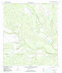
1969 Map of San Miguel Ranch
USGS Topo · Published 1971About this map
San Miguel Creek and its complex network of tributaries dictate the landscape of this South Texas region, where the Atascosa and McMullen county line cuts across ranch land and drainage basins. Surveyed in the late 1960s, the map reveals a transition from traditional pastoral sites like San Miguel Ranch to modern industrial infrastructure, evidenced by the prominent pipeline corridor and a Gravel Pit near the creek bends. Settlement remains sparse, represented by named locations such as Hinds and Lyons, which are connected by a system of winding roads and private tracks. The drainage patterns of Macho Creek and Lagunillas Creek define the local topography, showing the seasonal nature of water flow in this semi-arid environment, with several wells and the small Lake providing essential water points for livestock and land management.
Find a feature on this map
18 named features on this map. Tap any name to fly to it.
Don’t see what you’re looking for? This feature index may not catch every label — zoom into the map to look around manually.
Map Details
Editions of this 1969 San Miguel Ranch Map
2 editions found
Other maps of this area

1934 · Schattel
USGS Topo · 1:62,500

1953 · Crystal City
USGS Topo · 1:250,000

1955 · Crystal City
USGS Topo · 1:250,000

1956 · Jourdanton
USGS Topo · 1:62,500

1956 · Hindes
USGS Topo · 1:62,500

1956 · Franklin Settlement
USGS Topo · 1:62,500

1961 · Crystal City
USGS Topo · 1:250,000

1968 · Crystal City
USGS Topo · 1:250,000
1968 · Charlotte
USGS Topo · 1:24,000
1968 · Christine West
USGS Topo · 1:24,000