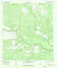
1969 Map of San Miguel Ranch
USGS Topo · Published 1991About this map
San Miguel Creek defines the low-lying drainage of this South Texas landscape, where the boundary between Atascosa Co and Mc Mullen Co meets in a region of ranching and early mineral extraction. The 1969 field-checked survey highlights a terrain interconnected by numerous watercourses, including the substantial Lagunillas Creek and its southern tributaries like Prairie Creek and Indian Creek. Settlement is sparse, anchored by the namesake San Miguel Ranch and the small communities of Hindes and Lyons. The presence of a Gravel Pit and a north-south Pipeline suggests the creeping industrialization of the brush country, while the predominance of private roads indicates a landscape still dominated by large-scale landholdings. This survey captures a moment of transition for these border counties, documenting the physical reality of the land before modern agricultural and energy developments further altered the drainage patterns of Raccoon Creek and Macho Creek.
Find a feature on this map
15 named features on this map. Tap any name to fly to it.
Don’t see what you’re looking for? This feature index may not catch every label — zoom into the map to look around manually.
Map Details
Editions of this 1969 San Miguel Ranch Map
2 editions found
Other maps of this area

1934 · Schattel
USGS Topo · 1:62,500

1953 · Crystal City
USGS Topo · 1:250,000

1955 · Crystal City
USGS Topo · 1:250,000

1956 · Jourdanton
USGS Topo · 1:62,500

1956 · Hindes
USGS Topo · 1:62,500

1956 · Franklin Settlement
USGS Topo · 1:62,500

1961 · Crystal City
USGS Topo · 1:250,000

1968 · Crystal City
USGS Topo · 1:250,000
1968 · Charlotte
USGS Topo · 1:24,000
1968 · Christine West
USGS Topo · 1:24,000