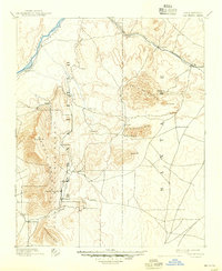
1892 Map of San Pedro
USGS Topo · Published 1944About this map
The Sandia Mountains and Ortiz Mountains anchor this late nineteenth-century landscape, revealing a network of mining and agricultural settlements connected by the Atchison Topeka and Santa Fe Railroad. Surveyed just as the New Mexico Territory was becoming increasingly integrated with the national rail system, the map tracks the industrial and social footprint of the era through mining hubs like San Pedro and Golden, alongside older communities such as Algodones on the Rio Grande.
Find a feature on this map
36 named features on this map. Tap any name to fly to it.
Don’t see what you’re looking for? This feature index may not catch every label — zoom into the map to look around manually.
Map Details
Editions of this 1892 San Pedro Map
5 editions found
Other maps of this area

1888 · Bernalillo
USGS Topo · 1:125,000

1889 · Albuquerque
USGS Topo · 1:125,000

1889 · Santa Fe
USGS Topo · 1:125,000

1890 · Jemes
USGS Topo · 1:125,000

1892 · San Pedro
USGS Topo · 1:125,000

1892 · Jemes
USGS Topo · 1:125,000

1892 · Santa Clara
USGS Topo · 1:125,000

1893 · Albuquerque
USGS Topo · 1:125,000

1894 · Santa Fe
USGS Topo · 1:125,000

1894 · Lamy
USGS Topo · 1:125,000