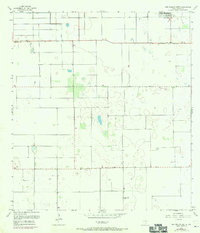
1956 Map of San Perlita South
USGS Topo · Published 1970About this map
San Perlita sits at the northern edge of this coastal prairie landscape, where the agricultural geometry of South Texas meets a complex system of drainage and irrigation. The map reveals an intensive effort to manage the local hydrology through an Elevated Ditch and various other water controls, likely supporting the nearby cotton and citrus industries of Willacy County. Industrial activity is anchored by the Los Coyotes Gin in the southern portion of the quadrangle, while smaller rural nodes like Porfirio and a localized Cem reflect the settlement patterns of ranching and farming families. Transportation is defined by functional routes such as Red Fish Bay Road and Parker Road, alongside a dedicated Landing Strip, illustrating the logistical needs of this productive agricultural era.
Find a feature on this map
11 named features on this map. Tap any name to fly to it.
Don’t see what you’re looking for? This feature index may not catch every label — zoom into the map to look around manually.
Map Details
Editions of this 1956 San Perlita South Map
3 editions found
Other maps of this area

1921 · Tarida Ranch
USGS Topo · 1:62,500

1922 · La Sal Vieja
USGS Topo · 1:62,500

1929 · Santa Rosa
USGS Topo · 1:24,000

1932 · Combes
USGS Topo · 1:31,680

1933 · Santa Rosa
USGS Topo · 1:31,680

1933 · Paso Real
USGS Topo · 1:31,680

1953 · Brownsville
USGS Topo · 1:250,000

1956 · San Perlita South
USGS Topo · 1:24,000

1956 · San Perlita North
USGS Topo · 1:24,000

1956 · Santa Rosa
USGS Topo · 1:24,000