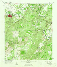
1959 Map of San Saba
USGS Topo · Published 1962About this map
San Saba serves as the focal point of this Central Texas landscape, situated at the confluence where the San Saba River nears its junction with the Colorado River. The town layout includes the local Courthouse, a Baseball Field, and a Landing Strip to the north, while the Gulf Colorado and Santa Fe RR cuts across the northern territory.
Find a feature on this map
81 named features on this map. Tap any name to fly to it.
Don’t see what you’re looking for? This feature index may not catch every label — zoom into the map to look around manually.
Map Details
Editions of this 1959 San Saba Map
This is the sole edition of this map. No revisions or reprints were ever made.
Other maps of this area

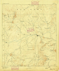
1885 · San Saba
USGS Topo · 1:125,000

1887 · Llano
USGS Topo · 1:125,000

1887 · Lampasas
USGS Topo · 1:125,000

1887 · Burnet
USGS Topo · 1:125,000

1893 · Burnet
USGS Topo · 1:125,000

1894 · Lampasas
USGS Topo · 1:125,000

1894 · San Saba
USGS Topo · 1:125,000
1894 · Llano
USGS Topo · 1:125,000

1903 · Burnet
USGS Topo · 1:125,000

1904 · Llano
USGS Topo · 1:125,000