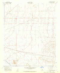
1947 Map of Sanborn
USGS Topo · Published 1961About this map
Freeman Valley dominates this high desert landscape, captured during a 1946 aerial survey and field-checked just after the war. The topography reveals a stark, arid environment defined by long-distance infrastructure rather than dense settlement. Two major rail corridors converge here, with the Southern Pacific line cutting through the northern sections and the Atchison Topeka and Santa Fe running along the southern edge. These transit lines signify the area's importance as a logistical artery in the Antelope Valley region.
Find a feature on this map
10 named features on this map. Tap any name to fly to it.
Don’t see what you’re looking for? This feature index may not catch every label — zoom into the map to look around manually.
Map Details
Editions of this 1947 Sanborn Map
3 editions found

Other maps of this area

1915 · Elizabeth Lake
USGS Topo · 1:125,000

1915 · Searles Lake
USGS Topo · 1:250,000

1915 · Mojave
USGS Topo · 1:125,000

1917 · Elizabeth Lake
USGS Topo · 1:125,000

1937 · Rogers Lake
USGS Topo · 1:48,000

1942 · Rogers Lake
USGS Topo · 1:62,500

1943 · Rosamond
USGS Topo · 1:62,500

1943 · Castle Butte
USGS Topo · 1:62,500

1943 · Mojave
USGS Topo · 1:62,500

1947 · Fluhr
USGS Topo · 1:24,000