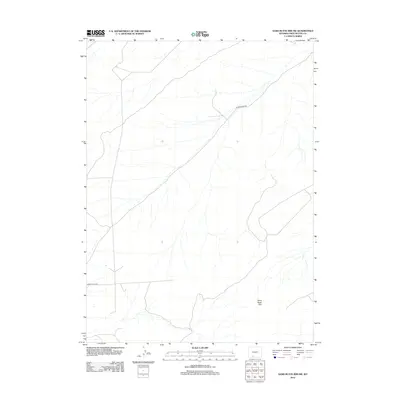
2012 Map of Sand Butte Rim NW
USGS Topo · Published 2012About this map
Sand Butte Rim dominates the eastern topography of this high desert landscape in Sweetwater County, marking a distinct elevation change in an otherwise open terrain. This 2012 survey illustrates the sparse industrial and utility infrastructure characteristic of Wyoming's resource-rich basins. The map focuses on a few critical access routes through the sagebrush, specifically Patrick Draw Rd and Brady Plant Rd, which provide passage through the arid plains. These roads serve as the primary lifelines through the region, linking remote points in the western Red Desert. The drainage patterns shown across the sheet reflect the seasonal movement of water toward the lower basins, defining the subtle ecological and geological character of this expansive Wyoming rangeland.
Find a feature on this map
3 named features on this map. Tap any name to fly to it.
Don’t see what you’re looking for? This feature index may not catch every label — zoom into the map to look around manually.
Map Details
Editions of this 2012 Sand Butte Rim NW Map
This is the sole edition of this map. No revisions or reprints were ever made.
Other maps of this area

1954 · Rock Springs
USGS Topo · 1:250,000

1958 · Rock Springs
USGS Topo · 1:250,000

1962 · Rock Springs
USGS Topo · 1:250,000

1968 · Cooper Ridge NE
USGS Topo · 1:24,000

1968 · Sand Butte Rim NW
USGS Topo · 1:24,000

1968 · Bitter Creek
USGS Topo · 1:24,000

1968 · Black Buttes
USGS Topo · 1:24,000

1968 · Pine Butte
USGS Topo · 1:24,000

1968 · Sand Butte Rim SE
USGS Topo · 1:24,000
1968 · Burley Draw
USGS Topo · 1:24,000