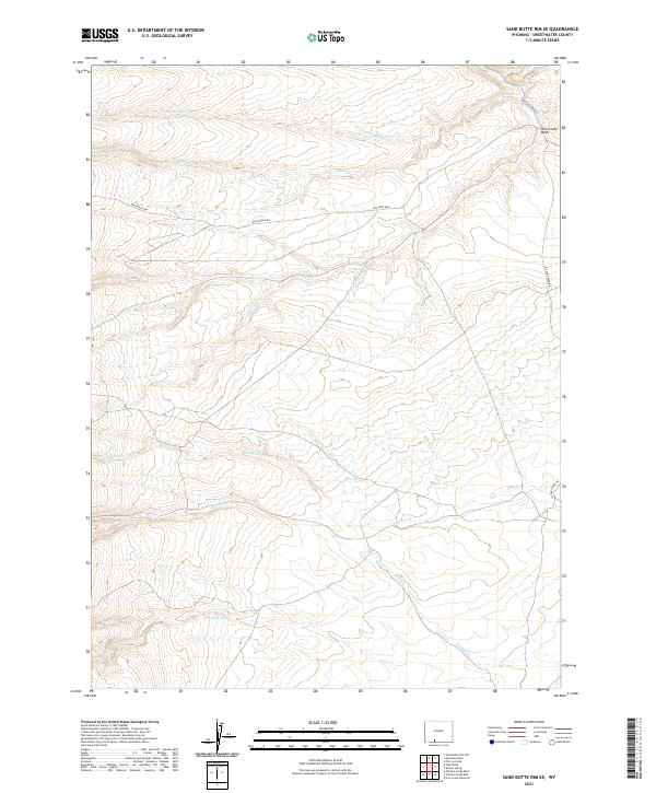
2021 Map of Sand Butte Rim SE
USGS Topo · Published 2021About this map
Rim Road 4408 traverses an arid and high-elevation landscape in Sweetwater County, crossing a complex network of seasonal drainages and washes. The terrain is defined by its hydraulic patterns, with systems like Kinney Cr and Shell Cr cutting through the open country. Evidence of water management is seen at the Dry Reservoir, while other natural features such as Pine Creek Wash and Dry Sand Cr illustrate the dry character of the high desert plateau. This area is also delineated by the Public Land Survey System grids of t16n r100w and t15n r99w, marking the administrative organization of these rural Wyoming lands in the early 21st century.
Find a feature on this map
15 named features on this map. Tap any name to fly to it.
Don’t see what you’re looking for? This feature index may not catch every label — zoom into the map to look around manually.
Map Details
Editions of this 2021 Sand Butte Rim SE Map
This is the sole edition of this map. No revisions or reprints were ever made.
Other maps of this area

1954 · Rock Springs
USGS Topo · 1:250,000

1958 · Rock Springs
USGS Topo · 1:250,000

1962 · Rock Springs
USGS Topo · 1:250,000

1968 · Chicken Creek East
USGS Topo · 1:24,000

1968 · Sand Butte Rim NW
USGS Topo · 1:24,000

1968 · Pine Butte
USGS Topo · 1:24,000

1968 · Sand Butte Rim SE
USGS Topo · 1:24,000
1968 · Antelope Flats
USGS Topo · 1:24,000
1968 · Chicken Creek West
USGS Topo · 1:24,000

1970 · Cow Creek Reservoir
USGS Topo · 1:24,000