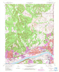
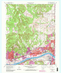
1956 Map of Sand Springs
USGS Topo · Published 1983About this map
The Arkansas River serves as the geographic anchor for this mid-century industrial and residential corridor. In Sand Springs, the landscape is defined by the heavy infrastructure of the Oil Refinery and the vital connection provided by the Sand Springs Railway. The map captures a moment of transition where the dense urban network of Tulsa and West Tulsa pushes against the Osage Indian Reservation Bdy. Notable civic and educational landmarks, such as Booker T Washington Sch and Woodland Cemetery, appear alongside extensive oil field developments and an active Quarry. Purple photorevision tints highlight significant urban expansion by the early 1980s, particularly around the northern hills and near the Downtown Airpark, while the riverbanks show the concentration of industrial works and schools like Eugene Field Sch that supported these growing neighborhoods.
Find a feature on this map
62 named features on this map. Tap any name to fly to it.
Don’t see what you’re looking for? This feature index may not catch every label — zoom into the map to look around manually.
Map Details
Editions of this 1956 Sand Springs Map
6 editions found

Other maps of this area

1901 · Claremore
USGS Topo · 1:125,000

1912 · Hominy
USGS Topo · 1:125,000

1914 · Claremore
USGS Topo · 1:125,000

1915 · Hominy
USGS Topo · 1:125,000

1916 · Claremore
USGS Topo · 1:125,000

1952 · Jenks
USGS Topo · 1:24,000

1954 · Tulsa
USGS Topo · 1:250,000

1954 · Tulsa
USGS Topo · 1:24,000

1955 · Sperry
USGS Topo · 1:24,000

1955 · Enid
USGS Topo · 1:250,000