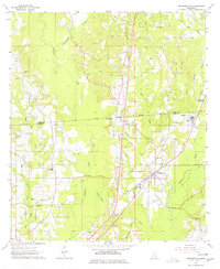
1964 Map of Sandersville
USGS Topo · Published 1977About this map
The Southern Railroad corridor defines the industrial and social landscape of this Jones County region, anchoring settlements like Sandersville and Errata. This mid-century survey captures the area during a period of active petroleum and timber extraction, evidenced by the extensive Oil Field operations and the presence of a Refinery near Markwald. Historical transit patterns are preserved through labels for the Old Indian Treaty Boundary and the Old Mayhew Road, which cut across the natural drainage of Tallahala Creek and Bogue Homo. Community life is centered around rural landmarks like Sandersville School and several country churches, including Mt Moriah Ch & Cem and Corinth Ch. The terrain is further marked by the Errata Lookout Tower and various resource sites like the Claypit and Gravel Pit, showing the intersection of local industry and the Mississippi landscape.
Find a feature on this map
46 named features on this map. Tap any name to fly to it.
Don’t see what you’re looking for? This feature index may not catch every label — zoom into the map to look around manually.
Map Details
Editions of this 1964 Sandersville Map
4 editions found
Other maps of this area

1953 · Hattiesburg
USGS Topo · 1:250,000

1958 · Hattiesburg
USGS Topo · 1:250,000

1963 · Waldrup
USGS Topo · 1:24,000

1963 · Heidelberg
USGS Topo · 1:24,000

1964 · Heidelberg SW
USGS Topo · 1:24,000

1964 · Moss
USGS Topo · 1:24,000

1964 · Sandersville
USGS Topo · 1:24,000

1964 · Laurel East
USGS Topo · 1:24,000

1964 · Laurel West
USGS Topo · 1:24,000

1964 · Myrick
USGS Topo · 1:24,000