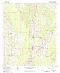
1964 Map of Sandersville
USGS Topo · Published 1982About this map
The Jasper Co Jones Co line bisects this landscape, which is marked by the industrial footprints of the Oil Field and a prominent Refinery. Sandersville serves as the primary hub, clustered around the Southern railroad line and the Sandersville Sch. The presence of the Old Indian Treaty Boundary Line cutting through the center of the sheet provides a significant historical anchor, reflecting earlier territorial divisions.
Find a feature on this map
48 named features on this map. Tap any name to fly to it.
Don’t see what you’re looking for? This feature index may not catch every label — zoom into the map to look around manually.
Map Details
Editions of this 1964 Sandersville Map
4 editions found
Other maps of this area

1953 · Hattiesburg
USGS Topo · 1:250,000

1958 · Hattiesburg
USGS Topo · 1:250,000

1963 · Waldrup
USGS Topo · 1:24,000

1963 · Heidelberg
USGS Topo · 1:24,000

1964 · Heidelberg SW
USGS Topo · 1:24,000

1964 · Moss
USGS Topo · 1:24,000

1964 · Sandersville
USGS Topo · 1:24,000

1964 · Laurel East
USGS Topo · 1:24,000

1964 · Laurel West
USGS Topo · 1:24,000

1964 · Myrick
USGS Topo · 1:24,000