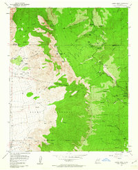
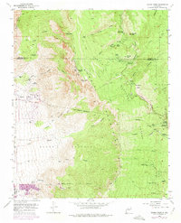
1961 Map of Sandia Crest
USGS Topo · Published 1962About this map
The Sandia Mountains dominate this 1961 survey, revealing a landscape defined by the tension between early recreational development and ancient land grants. Within the Cibola National Forest, the map traces the rise of high-altitude leisure, from the Tree Spring Winter Sports Area and La Madera Ski Area to the remote Kiwani Cabin near the 10,678-foot peak. A quiet industrial history is marked by the La Luz Mine and the presence of numerous Radio Towers atop the crest.
Find a feature on this map
65 named features on this map. Tap any name to fly to it.
Don’t see what you’re looking for? This feature index may not catch every label — zoom into the map to look around manually.
Map Details
Editions of this 1961 Sandia Crest Map
5 editions found
Other maps of this area

1888 · Bernalillo
USGS Topo · 1:125,000

1889 · Albuquerque
USGS Topo · 1:125,000

1892 · San Pedro
USGS Topo · 1:125,000

1893 · Albuquerque
USGS Topo · 1:125,000

1934 · Alameda
USGS Topo · 1:24,000

1934 · East Albuquerque
USGS Topo · 1:24,000

1938 · Albuquerque
USGS Topo · 1:62,500

1954 · Sandia Crest
USGS Topo · 1:24,000

1954 · Alameda
USGS Topo · 1:24,000

1954 · Placitas
USGS Topo · 1:24,000
Featured Places
- Albuquerque, NM
- Cedar Crest, NM
- Evergreen Hills Subdivision, NM
- Cooper LS Ranch, NM
- Glenwood Hills, Albuquerque