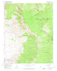
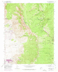
1961 Map of Sandia Crest
USGS Topo · Published 1974About this map
Sandia Crest dominates this topographic landscape along the border of Sandoval and Bernalillo counties, rising above a network of deep canyons and seasonal arroyos. The 1961 survey captures the area's development as a regional recreation hub within the Cibola National Forest, featuring the Sandia Peak Tramway, the La Madera Ski Area, and the Tree Spring Winter Sports Area. This era of development is juxtaposed with older land uses, marked by the Sandia Pueblo Grant Boundary and the Elena Gallegos Grant Boundary. Local history is preserved in the location of the Cañoncito Cemetery and several isolated dwellings such as Ellis Ranch, Juan Tabo Cabin, and Kiwani Cabin. The map details numerous public spaces, including the Sandia Conference Ground and multiple picnic areas like Doc Long Picnic Area and Balsam Glade Picnic Area, showing how the mountains were utilized for both spiritual retreat and active recreation.
Find a feature on this map
64 named features on this map. Tap any name to fly to it.
Don’t see what you’re looking for? This feature index may not catch every label — zoom into the map to look around manually.
Map Details
Editions of this 1961 Sandia Crest Map
5 editions found
Other maps of this area

1888 · Bernalillo
USGS Topo · 1:125,000

1889 · Albuquerque
USGS Topo · 1:125,000

1892 · San Pedro
USGS Topo · 1:125,000

1893 · Albuquerque
USGS Topo · 1:125,000

1934 · Alameda
USGS Topo · 1:24,000

1934 · East Albuquerque
USGS Topo · 1:24,000

1938 · Albuquerque
USGS Topo · 1:62,500

1954 · Sandia Crest
USGS Topo · 1:24,000

1954 · Alameda
USGS Topo · 1:24,000

1954 · Placitas
USGS Topo · 1:24,000
Featured Places
- Albuquerque, NM
- Cedar Crest, NM
- Evergreen Hills Subdivision, NM
- Cooper LS Ranch, NM
- Glenwood Hills, Albuquerque