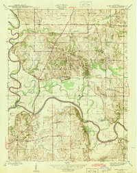
1945 Map of Sandy Hook
USGS Topo · Published 1945About this map
The West Fork White River dictates the landscape of this Indiana river-bottom region during the mid-1940s, winding through the corners of Daviess, Knox, and Pike counties. The settlement at Sandy Hook serves as a local landmark near the river's bend, while the surrounding rural landscape in Veale and Washington townships is densely dotted with neighborhood schools and churches. These community hubs, including Needmore Sch, Whittier Sch, and Mt Olive Ch, reflect a distributed settlement pattern common before post-war school consolidations. Along the Central Indiana railroad line, industrial activity is marked by a Strip Mine south of Jackson Pond, showing the early footprint of surface mining in the area. Numerous oxbow water bodies like Horseshoe Pond and Chew Pond illustrate the shifting path of the river over time, defining the fertile but flood-prone terrain.
Find a feature on this map
34 named features on this map. Tap any name to fly to it.
Don’t see what you’re looking for? This feature index may not catch every label — zoom into the map to look around manually.
Map Details
Editions of this 1945 Sandy Hook Map
2 editions found
Other maps of this area

1902 · Ditney
USGS Topo · 1:125,000

1903 · Velpen
USGS Topo · 1:62,500

1903 · Petersburg
USGS Topo · 1:62,500

1944 · Montgomery
USGS Topo · 1:24,000

1944 · Glendale
USGS Topo · 1:24,000

1944 · Washington
USGS Topo · 1:24,000

1944 · Monroe City
USGS Topo · 1:24,000

1944 · Wheatland
USGS Topo · 1:24,000

1945 · Sandy Hook
USGS Topo · 1:24,000

1956 · Vincennes
USGS Topo · 1:250,000