
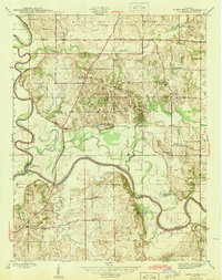
1945 Map of Sandy Hook
USGS Topo · Published 1945About this map
The East Fork White River and White River converge in this mid-century survey of the Indiana countryside, defining the borders of Daviess, Knox, and Pike counties. The landscape is marked by a dense network of local education and faith, featuring numerous country schools like Letts Sch, Scudder Sch, and Swan Sch, alongside rural congregations at Bethel Ch and Aikman Ch. In the northern section, Thomas Bluff rises above the lowlands of Veale Creek, while the southwestern corner shows the industrial footprint of a Strip Mine. Geographers and local historians will note the path of the Central Canal running north-south, and the scattering of river-adjacent water bodies such as Chew Pond and Horseshoe Pond that indicate the shifting nature of the river valley's drainage before modern management.
Find a feature on this map
36 named features on this map. Tap any name to fly to it.
Don’t see what you’re looking for? This feature index may not catch every label — zoom into the map to look around manually.
Map Details
Editions of this 1945 Sandy Hook Map
2 editions found
Other maps of this area

1902 · Ditney
USGS Topo · 1:125,000

1903 · Velpen
USGS Topo · 1:62,500

1903 · Petersburg
USGS Topo · 1:62,500

1944 · Montgomery
USGS Topo · 1:24,000

1944 · Glendale
USGS Topo · 1:24,000

1944 · Washington
USGS Topo · 1:24,000

1944 · Monroe City
USGS Topo · 1:24,000

1944 · Wheatland
USGS Topo · 1:24,000

1956 · Vincennes
USGS Topo · 1:250,000

1957 · Vincennes
USGS Topo · 1:250,000