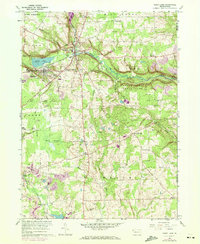
1960 Map of Sandy Lake
USGS Topo · Published 1972About this map
Sandy Lake and Stoneboro serve as the primary hubs in this western Pennsylvania landscape, where the Penn Central railroad tracks trace the valley of Sandy Creek. The 1960s economy is clearly visible through the extensive network of resource extraction, with strip mines, mine dumps, and numerous gas wells dotting the hillsides and forested tracts. Rural life is anchored by family-named landmarks like Perrine Corners and Hendersonville, while the Lakeview Consolidated High School reflects the era's educational consolidation. Significant portions of the eastern terrain are dedicated to State Game Lands No 130, which preserves wilder reaches around McConnell Run. Genealogists will find several burial sites including Oak Hill Cem and the Yankee Hill Cem, alongside historical markers like Reeds Furnace near the Venango County line.
Find a feature on this map
49 named features on this map. Tap any name to fly to it.
Don’t see what you’re looking for? This feature index may not catch every label — zoom into the map to look around manually.
Map Details
Editions of this 1960 Sandy Lake Map
3 editions found
Other maps of this area

1909 · Franklin
USGS Topo · 1:62,500

1910 · Hilliards
USGS Topo · 1:62,500

1911 · Franklin
USGS Topo · 1:62,500

1911 · Stoneboro
USGS Topo · 1:62,500

1912 · Hilliards
USGS Topo · 1:62,500

1913 · Stoneboro
USGS Topo · 1:62,500

1913 · Mercer
USGS Topo · 1:62,500

1939 · Mercer
USGS Topo · 1:62,500

1943 · Mercer
USGS Topo · 1:62,500

1943 · Stoneboro
USGS Topo · 1:62,500