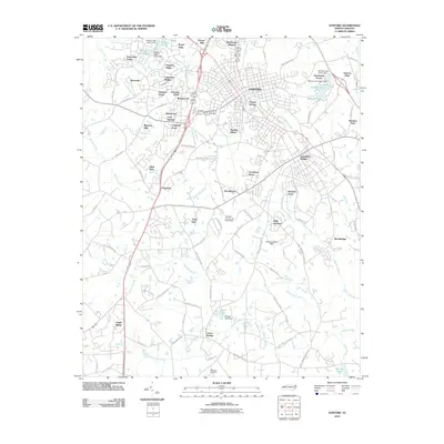
2010 Map of Sanford
USGS Topo · Published 2010About this map
Sanford and its surrounding Lee County neighborhoods are mapped here during a period of significant suburban expansion and industrial activity. The landscape is defined by the headwaters of the Upper Little River and numerous tributaries like Big Buffalo Creek and Persimmon Creek, which are segmented by man-made features including Holiday Lake and Oldhams Lake. Residential developments such as Jonesboro Heights, Forest Hills, and McCracken Heights illustrate the city's outward growth, while the Sanford-Lee County Brick Field points to the region's long-standing connection to the clay and brick-making industry. To the south, the settlement of Lemon Springs and the rural crossroads of Tramway represent older community hubs. Genealogists may find the McQueen Cemetery near the southern boundary particularly useful for tracing local family history in this Piedmont landscape.
Find a feature on this map
102 named features on this map. Tap any name to fly to it.
Don’t see what you’re looking for? This feature index may not catch every label — zoom into the map to look around manually.
Map Details
Editions of this 2010 Sanford Map
This is the sole edition of this map. No revisions or reprints were ever made.
Other maps of this area

1953 · Raleigh
USGS Topo · 1:250,000

1954 · Raleigh
USGS Topo · 1:250,000

1957 · Murchisontown
USGS Topo · 1:24,000
1957 · Olivia
USGS Topo · 1:24,000

1970 · Goldston
USGS Topo · 1:24,000

1970 · Colon
USGS Topo · 1:24,000

1970 · Moncure
USGS Topo · 1:24,000

1974 · White Hill
USGS Topo · 1:24,000
1974 · Vass
USGS Topo · 1:24,000

1974 · Sanford
USGS Topo · 1:24,000