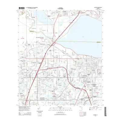
2015 Map of Sanford
USGS Topo · Published 2015About this map
The Saint Johns River corridor and the expansive Lake Monroe dominate this central Florida landscape, marking the historical and ecological boundary between Volusia and Seminole counties. The city of Sanford serves as a major hub, its street grid extending southward toward Lake Mary and westward into a cluster of distinct communities such as New Upsala, Saint Josephs, and Paola. This 2015 survey illustrates the dense integration of transportation networks, where the CSX Transportation line and Florida's Turnpike cut through a terrain dappled with smaller water bodies like Sylvan Lake, Crystal Lake, and Lake Ada. Cultural landmarks such as Restlawn Cem and Oaklawn Memorial Park provide points of reference for genealogists, while smaller settlements like Bookertown and Lincoln Heights reflect the area's complex residential development and local history.
Find a feature on this map
107 named features on this map. Tap any name to fly to it.
Don’t see what you’re looking for? This feature index may not catch every label — zoom into the map to look around manually.
Map Details
Editions of this 2015 Sanford Map
This is the sole edition of this map. No revisions or reprints were ever made.
Other maps of this area

1955 · Orlando
USGS Topo · 1:250,000

1956 · Oviedo
USGS Topo · 1:24,000

1957 · Orlando
USGS Topo · 1:250,000

1958 · Orlando
USGS Topo · 1:250,000

1959 · Forest City
USGS Topo · 1:24,000

1962 · Orlando
USGS Topo · 1:250,000

1962 · Pine Lakes
USGS Topo · 1:24,000

1962 · Casselberry
USGS Topo · 1:24,000
1964 · Orange City
USGS Topo · 1:24,000
1965 · Sanford SW
USGS Topo · 1:24,000