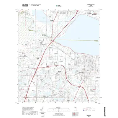
2018 Map of Sanford
USGS Topo · Published 2018About this map
Lake Monroe serves as the central focal point for this region, bordered by the established communities of Sanford and Debary. The modern landscape is characterized by its complex hydrology, where the Saint Johns River feeds into expansive waters like Mullet Lake and Konomac Lake, creating a network of islands including Alexander Island and Rossiter Island. This 2018 survey documents a dense residential and institutional environment, featuring the sprawling grounds of the Orlando Sanford International Airport and academic centers like Seminole State College. Pockets of local history are preserved in the numerous named cemeteries such as Lock Arbor Cem and Sanford Cem, while the Florida National Scenic Trail winds through the western terrain. The transition from industrial transport hubs like Benson Junction and Valdez to the suburban developments of Highland Park and New Upsala illustrates the continued evolution of this Volusia and Seminole County corridor.
Find a feature on this map
87 named features on this map. Tap any name to fly to it.
Don’t see what you’re looking for? This feature index may not catch every label — zoom into the map to look around manually.
Map Details
Editions of this 2018 Sanford Map
This is the sole edition of this map. No revisions or reprints were ever made.
Other maps of this area

1955 · Orlando
USGS Topo · 1:250,000

1956 · Oviedo
USGS Topo · 1:24,000

1957 · Orlando
USGS Topo · 1:250,000

1958 · Orlando
USGS Topo · 1:250,000

1959 · Forest City
USGS Topo · 1:24,000

1962 · Orlando
USGS Topo · 1:250,000

1962 · Pine Lakes
USGS Topo · 1:24,000

1962 · Casselberry
USGS Topo · 1:24,000
1964 · Orange City
USGS Topo · 1:24,000
1965 · Sanford SW
USGS Topo · 1:24,000