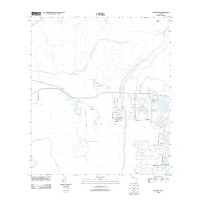
2012 Map of Sanford SW
USGS Topo · Published 2012About this map
The Wekiva River defines the central corridor of this Florida landscape, where suburban residential expansion meets a complex network of wetlands and tributaries. Established communities such as Wekiva and Markham are joined by newer developments like Alaqua Lakes and the Lehigh Golf and Resort, illustrating the rapid growth of the region in the early 21st century. To the north, the terrain remains less developed, marked by the winding courses of Black Water Cr and Sulphur Run, eventually giving way to the open expanse known as The Prairie. Smaller settlements like Walling and Ethel sit along the primary road arteries, while numerous local water bodies, including Sylvan Lake and Lake Markham, dot the eastern half of the map. This survey serves as a detailed record of land use at a time when traditional natural landmarks and modern residential infrastructure coexist along the river's edge.
Find a feature on this map
60 named features on this map. Tap any name to fly to it.
Don’t see what you’re looking for? This feature index may not catch every label — zoom into the map to look around manually.
Map Details
Editions of this 2012 Sanford SW Map
This is the sole edition of this map. No revisions or reprints were ever made.
Other maps of this area

1955 · Orlando
USGS Topo · 1:250,000

1957 · Orlando
USGS Topo · 1:250,000

1958 · Orlando
USGS Topo · 1:250,000

1959 · Forest City
USGS Topo · 1:24,000

1960 · Sorrento
USGS Topo · 1:24,000

1960 · Apopka
USGS Topo · 1:24,000

1962 · Orlando
USGS Topo · 1:250,000

1962 · Pine Lakes
USGS Topo · 1:24,000

1962 · Casselberry
USGS Topo · 1:24,000
1964 · Orange City
USGS Topo · 1:24,000