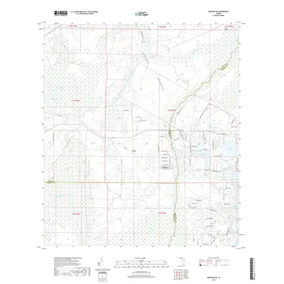
2018 Map of Sanford SW
USGS Topo · Published 2018About this map
Ethel and Wekiva appear as quiet central nodes in this landscape where the borders of Lake, Seminole, and Orange counties converge. The hydrology of the region is the dominant force, shaped by the Wekiva River and the winding course of Black Water Cr. Extensive wetlands like the Seminole Swamp and Wekiva Swamp illustrate the low-lying character of the terrain before it gives way to a dense network of residential lakes to the east. The Florida National Scenic Trail cuts a long path through the center of the sheet, providing a corridor for exploration through the brush and wetlands. To the northeast, the terrain opens into a distinctive area known as The Prairie, while the eastern portion of the map is defined by a high concentration of small water bodies, including Yankee Lake, Sylvan Lake, and Lake Markham, reflecting the post-war residential expansion of Central Florida.
Find a feature on this map
84 named features on this map. Tap any name to fly to it.
Don’t see what you’re looking for? This feature index may not catch every label — zoom into the map to look around manually.
Map Details
Editions of this 2018 Sanford SW Map
This is the sole edition of this map. No revisions or reprints were ever made.
Other maps of this area

1955 · Orlando
USGS Topo · 1:250,000

1957 · Orlando
USGS Topo · 1:250,000

1958 · Orlando
USGS Topo · 1:250,000

1959 · Forest City
USGS Topo · 1:24,000

1960 · Sorrento
USGS Topo · 1:24,000

1960 · Apopka
USGS Topo · 1:24,000

1962 · Orlando
USGS Topo · 1:250,000

1962 · Pine Lakes
USGS Topo · 1:24,000

1962 · Casselberry
USGS Topo · 1:24,000
1964 · Orange City
USGS Topo · 1:24,000