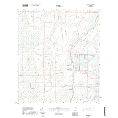
2021 Map of Sanford SW
USGS Topo · Published 2021About this map
Ethel and Wekiva anchor this landscape at the intersection of Lake, Seminole, and Orange Counties, where the Central Florida wilderness meets expanding residential developments. The area is defined by a dense network of conservation lands, including the Rock Springs Run State Reserve and Lower Wekiva River Preserve State Park, which protect the critical hydrologic systems of Black Water Cr and Rock Springs Run. For genealogists and local historians, the presence of the Ethel Cem offers a tangible link to the early citrus and timber-era settlements that once thrived here before the land was largely dedicated to state preservation. Modern suburban growth is visible along the eastern edge near Sylvan Lake and Lake Markham, contrasting sharply with the primitive backcountry traversed by the Florida National Scenic Trl. The transition from the saturated Seminole Swamp to the open stretches of The Prairie illustrates the diverse ecosystem of the Wekiva River basin.
Find a feature on this map
100 named features on this map. Tap any name to fly to it.
Don’t see what you’re looking for? This feature index may not catch every label — zoom into the map to look around manually.
Map Details
Editions of this 2021 Sanford SW Map
This is the sole edition of this map. No revisions or reprints were ever made.
Other maps of this area

1955 · Orlando
USGS Topo · 1:250,000

1957 · Orlando
USGS Topo · 1:250,000

1958 · Orlando
USGS Topo · 1:250,000

1959 · Forest City
USGS Topo · 1:24,000

1960 · Sorrento
USGS Topo · 1:24,000

1960 · Apopka
USGS Topo · 1:24,000

1962 · Orlando
USGS Topo · 1:250,000

1962 · Pine Lakes
USGS Topo · 1:24,000

1962 · Casselberry
USGS Topo · 1:24,000
1964 · Orange City
USGS Topo · 1:24,000