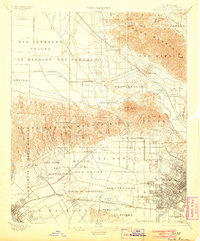
1902 Map of Santa Monica
USGS Topo · Published 1906About this map
Santa Monica Mountains and the San Fernando Valley define the landscape of this 1893 survey, showing Los Angeles in a period of rapid transition. Massive Spanish land grants such as La Brea, Rodeo de Las Aguas, and San Vicente y Santa Monica still serve as the primary geographic dividers, overlaid by a burgeoning rail network. The Pacific Electric Ry. and Southern Pacific R. R. connect emerging independent towns like Hollywood, Sherman, and Palms. While many areas remain open washes and canyons, the grid of S. Los Angeles is already densifying near the University. From the Soldiers Home to the small settlement of Ivanhoe, the map documents a semi-rural era where Cahuenga Pass was a simple transit point between valleys rather than the major corridor it would later become.
Find a feature on this map
76 named features on this map. Tap any name to fly to it.
Don’t see what you’re looking for? This feature index may not catch every label — zoom into the map to look around manually.
Map Details
Editions of this 1902 Santa Monica Map
4 editions found

Other maps of this area

1894 · Los Angeles
USGS Topo · 1:62,500

1896 · Pasadena
USGS Topo · 1:62,500

1896 · Redondo
USGS Topo · 1:62,500

1896 · Santa Monica
USGS Topo · 1:62,500

1896 · Downey
USGS Topo · 1:62,500

1898 · Santa Monica
USGS Topo · 1:62,500

1899 · Downey
USGS Topo · 1:62,500

1900 · Pasadena
USGS Topo · 1:62,500

1900 · Tujunga
USGS Topo · 1:62,500

1900 · Los Angeles
USGS Topo · 1:62,500