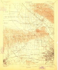
1902 Map of Santa Monica
USGS Topo · Published 1910About this map
The Santa Monica Mountains dominate this early landscape, separating the vast San Fernando Valley from the burgeoning settlements of the Los Angeles basin. In this era, the region is defined by Spanish land grants and ranchos such as La Brea, Rodeo de las Aguas, and San Jose de Buenos Ayres. Settlement patterns follow the railroads, with the Southern Pacific R. R. and the Chatsworth Park Branch connecting small hubs like Burbank, Toluca, and Kester.
Find a feature on this map
74 named features on this map. Tap any name to fly to it.
Don’t see what you’re looking for? This feature index may not catch every label — zoom into the map to look around manually.
Map Details
Editions of this 1902 Santa Monica Map
4 editions found

Other maps of this area

1894 · Los Angeles
USGS Topo · 1:62,500

1896 · Pasadena
USGS Topo · 1:62,500

1896 · Redondo
USGS Topo · 1:62,500

1896 · Santa Monica
USGS Topo · 1:62,500

1896 · Downey
USGS Topo · 1:62,500

1898 · Santa Monica
USGS Topo · 1:62,500

1899 · Downey
USGS Topo · 1:62,500

1900 · Pasadena
USGS Topo · 1:62,500

1900 · Tujunga
USGS Topo · 1:62,500

1900 · Los Angeles
USGS Topo · 1:62,500