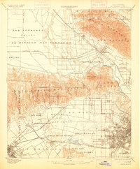
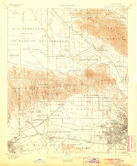
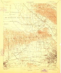
1902 Map of Santa Monica
USGS Topo · Published 1913About this map
The Santa Monica Mountains and the San Fernando Valley define the geography of this early twentieth-century survey, illustrating Los Angeles before its mid-century urban expansion. Large tracts of land remain organized under old Spanish and Mexican land grants, such as Rodeo de Las Aguas, La Brea, and Ex Mission San Fernando. These historic boundaries persist even as new settlements like Hollywood and Burbank begin to take shape along the rail lines.
Find a feature on this map
74 named features on this map. Tap any name to fly to it.
Don’t see what you’re looking for? This feature index may not catch every label — zoom into the map to look around manually.
Map Details
Editions of this 1902 Santa Monica Map
4 editions found

Other maps of this area

1894 · Los Angeles
USGS Topo · 1:62,500

1896 · Pasadena
USGS Topo · 1:62,500

1896 · Redondo
USGS Topo · 1:62,500

1896 · Santa Monica
USGS Topo · 1:62,500

1896 · Downey
USGS Topo · 1:62,500

1898 · Santa Monica
USGS Topo · 1:62,500

1899 · Downey
USGS Topo · 1:62,500

1900 · Pasadena
USGS Topo · 1:62,500

1900 · Tujunga
USGS Topo · 1:62,500

1900 · Los Angeles
USGS Topo · 1:62,500