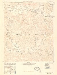
1947 Map of Santa Rosa Hills
USGS Topo · Published 1947About this map
The Santa Ynez River carves its way through a complex landscape of coastal ranges just after the war, as documented by the Army Map Service. This interior section of Santa Barbara County reveals a network of canyons and watercourses like Canada de la Santa Rosa and El Jaro Creek that define the boundaries between the Santa Rita Hills, the Santa Rosa Hills, and the towering Santa Ynez Mountains. The map provides a detailed view of the rural infrastructure of the late 1940s, marking the remote San Julian School and the Rinconada Church as central points of community life. Large land holdings like Rancho Los Alamos and the small settlement at Anita show the persistent influence of historic land grants on the region's development. This survey, compiled from 1942 aerial photography and field-edited in 1947, reflects the rugged character of the Salsipuedes area during an era of significant post-war transition in California.
Find a feature on this map
15 named features on this map. Tap any name to fly to it.
Don’t see what you’re looking for? This feature index may not catch every label — zoom into the map to look around manually.
Map Details
Editions of this 1947 Santa Rosa Hills Map
2 editions found
Other maps of this area

1905 · Lompoc
USGS Topo · 1:125,000

1942 · Lompoc
USGS Topo · 1:125,000

1942 · Lompoc
USGS Topo · 1:62,500

1942 · Pt. Conception
USGS Topo · 1:62,500

1942 · Gaviota
USGS Topo · 1:62,500

1942 · Los Olivos
USGS Topo · 1:62,500

1943 · Los Olivos
USGS Topo · 1:62,500

1943 · Lompoc
USGS Topo · 1:125,000

1943 · Gaviota
USGS Topo · 1:62,500

1947 · Lompoc
USGS Topo · 1:24,000