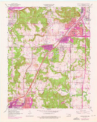
1956 Map of Sapulpa North
USGS Topo · Published 1976About this map
Sapulpa and Tulsa anchor this mid-century portrait of northeastern Oklahoma, where the Arkansas River and Turner Turnpike define the region's transport and industrial footprint. The map documents a transition from established urban centers to more rural outposts, evidenced by the clustered settlements of Oakhurst, Carbondale, and Prattville. Industrial activity is centered around the Oil Refinery in the northeast, while the St Louis San Francisco RR and Tulsa Sapulpa Union RR lines stitch together the various neighborhoods and outlying districts.
Find a feature on this map
50 named features on this map. Tap any name to fly to it.
Don’t see what you’re looking for? This feature index may not catch every label — zoom into the map to look around manually.
Map Details
Editions of this 1956 Sapulpa North Map
4 editions found

Other maps of this area

1896 · Okmulgee
USGS Topo · 1:125,000

1900 · Okmulgee
USGS Topo · 1:125,000

1901 · Claremore
USGS Topo · 1:125,000

1901 · Nuyaka
USGS Topo · 1:125,000

1912 · Hominy
USGS Topo · 1:125,000

1914 · Kiefer
USGS Topo · 1:62,500

1914 · Claremore
USGS Topo · 1:125,000

1915 · Hominy
USGS Topo · 1:125,000

1916 · Kiefer
USGS Topo · 1:62,500

1916 · Claremore
USGS Topo · 1:125,000