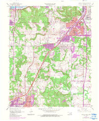
1956 Map of Sapulpa North
USGS Topo · Published 1983About this map
The industrial corridor between Tulsa and Sapulpa reveals a landscape defined by petroleum production and mid-century suburban expansion. An extensive Oil Refinery sits along the Arkansas River near Sand Springs, anchoring the region's economy. The terrain transitions from the heights of Lookout Mountain and Turkey Mountain Park down into the valleys of Nickel Creek and Polecat Creek, where small settlements and community landmarks are clustered. Significant local institutions appear throughout the district, including the Indian Mission, Little Cussetah Ch, and St Catherine Sch. This document, based on 1956 data with 1980s updates, captures the growth of neighborhoods like Carbondale and Oakhurst as they filled the gaps between the older rail-connected centers of Jenks and Garden City, driven by the proximity of the Burlington Northern railroad and the burgeoning highway network.
Find a feature on this map
42 named features on this map. Tap any name to fly to it.
Don’t see what you’re looking for? This feature index may not catch every label — zoom into the map to look around manually.
Map Details
Editions of this 1956 Sapulpa North Map
4 editions found

Other maps of this area

1896 · Okmulgee
USGS Topo · 1:125,000

1900 · Okmulgee
USGS Topo · 1:125,000

1901 · Claremore
USGS Topo · 1:125,000

1901 · Nuyaka
USGS Topo · 1:125,000

1912 · Hominy
USGS Topo · 1:125,000

1914 · Kiefer
USGS Topo · 1:62,500

1914 · Claremore
USGS Topo · 1:125,000

1915 · Hominy
USGS Topo · 1:125,000

1916 · Kiefer
USGS Topo · 1:62,500

1916 · Claremore
USGS Topo · 1:125,000