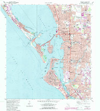
1973 Map of Sarasota
USGS Topo · Published 1987About this map
Sarasota and its barrier islands are captured during a period of significant coastal development and institutional growth. The urban grid extends east from the Sarasota Bay waterfront, where the Payne Terminal and Civic Center anchor the downtown core. The landscape is defined by the intricate relationship between the mainland and its keys, connected by causeways passing through Bird Key and Golden Gate Point. Residential patterns show established neighborhoods like Sarasota Heights and Beverley Terrace alongside numerous educational landmarks such as the Booker Schools and Alta Vista Sch. Further south, the meandering Phillippi Creek flows toward Roberts Bay, while the Gulf side features the expansive beaches of Lido Key and Siesta Key. This 1970s survey preserves the layout of the region before the intense modern intensification, showing the original footprints of local institutions like the Sarasota Vocational Sch and Doctors Hospital.
Find a feature on this map
69 named features on this map. Tap any name to fly to it.
Don’t see what you’re looking for? This feature index may not catch every label — zoom into the map to look around manually.
Map Details
Editions of this 1973 Sarasota Map
3 editions found
Other maps of this area

1943 · Laurel
USGS Topo · 1:24,000

1944 · Bird Keys
USGS Topo · 1:31,680

1944 · Sarasota
USGS Topo · 1:31,680

1944 · Laurel
USGS Topo · 1:31,680

1944 · Lorraine
USGS Topo · 1:31,680

1944 · Bradenton Beach
USGS Topo · 1:31,680

1947 · Bradenton
USGS Topo · 1:24,000

1947 · Bee Ridge
USGS Topo · 1:24,000

1956 · Tampa
USGS Topo · 1:250,000

1959 · Tampa
USGS Topo · 1:250,000