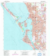
1973 Map of Sarasota
USGS Topo · Published 1992About this map
Sarasota and its sprawling coastal barrier islands are depicted in this 1970s era survey, capturing the region's mid-century expansion and maritime orientation. The map illustrates the complex waterway system of Sarasota Bay and Roberts Bay, joined to the Gulf of Mexico by Big Sarasota Pass and New Pass. Landmark causeways like the Ringling Causeway connect the mainland to developed keys, including St Armands Key, Lido Key, and Bird Key.
Find a feature on this map
86 named features on this map. Tap any name to fly to it.
Don’t see what you’re looking for? This feature index may not catch every label — zoom into the map to look around manually.
Map Details
Editions of this 1973 Sarasota Map
3 editions found
Other maps of this area

1943 · Laurel
USGS Topo · 1:24,000

1944 · Bird Keys
USGS Topo · 1:31,680

1944 · Sarasota
USGS Topo · 1:31,680

1944 · Laurel
USGS Topo · 1:31,680

1944 · Lorraine
USGS Topo · 1:31,680

1944 · Bradenton Beach
USGS Topo · 1:31,680

1947 · Bradenton
USGS Topo · 1:24,000

1947 · Bee Ridge
USGS Topo · 1:24,000

1956 · Tampa
USGS Topo · 1:250,000

1959 · Tampa
USGS Topo · 1:250,000