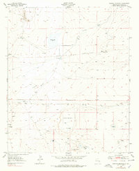
1949 Map of Sardine Mountain
USGS Topo · Published 1979About this map
El Camino Del Diablo cuts across this high-desert landscape in Chaves County, marking a route through a region defined by scattered water improvements and seasonal basins. In the late 1940s, this area supported modest ranching operations, as evidenced by numerous named watering points such as Morning Glory Tank, Antelope Tank, and Jackson Well. The topography is dominated by the Armstrong Basin in the south and Sardine Mountain in the northwest, with a distinct Diabase Dike cutting through the center of the sheet. Evidence of mid-century military activity is visible at the Air Force Bombing Range (Aband) near Alkali Lake. Other specialized features like the Race Track Well and the abandoned Morrisey Well suggest the shifting footprint of human activity in this arid corridor.
Find a feature on this map
26 named features on this map. Tap any name to fly to it.
Don’t see what you’re looking for? This feature index may not catch every label — zoom into the map to look around manually.
Map Details
Editions of this 1949 Sardine Mountain Map
2 editions found
Other maps of this area

1949 · Sardine Mountain
USGS Topo · 1:24,000

1949 · Wade Ranch
USGS Topo · 1:24,000

1949 · Malstrom Ranch
USGS Topo · 1:24,000

1949 · L-E Ranch
USGS Topo · 1:24,000

1954 · Brownfield
USGS Topo · 1:250,000

1955 · Roswell
USGS Topo · 1:250,000

1958 · Brownfield
USGS Topo · 1:250,000

1958 · Roswell
USGS Topo · 1:250,000

1962 · Roswell
USGS Topo · 1:250,000

1962 · Brownfield
USGS Topo · 1:250,000